Basic HTML Version


Salihli, Manisa’n›n en kalabal›k
nüfusa sahip ilçelerinden bir tanesidir.
M.Ö. 547’ye kadar Lidyal›lar›n
kontrolünde olan kent, daha sonra
Persler taraf›ndan fethedilmifl ve M.Ö.
334’e dek Perslerin elinde kalm›flt›r.
Daha sonra Roma ve Bizans
‹mparatorluklar›n›n egemenli¤ine
giren Salihli, 1400’de Osmanl›
‹mparatorlu¤u taraf›ndan
fethedilmifltir. Tar›m, tar›ma dayal›
ticaret ve sanayi flehrin bafll›ca geçim
kaynaklar›d›r. ‹lçede, üzüm, bu¤day,
pamuk, tütün ve m›s›r üretimi yap›l›r.
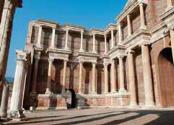
Kurflunlu Kapl›calar› ilçedeki turistik
yerlerden bir tanesidir.
Salihli is one of the most crowded
counties of Manisa city. Until 547
BC, Salihli was under control of
Lydians. Later it was conquered by
Persians and remained under Persian
rule until 334 BC. Salihli later became
a part of Roman and Byzantine
Empires before it was acquired by
Ottoman Empire in 1400. Agriculture,
trade and industry are leading
economical sources. Grape, wheat,
cotton, tobacco and corn are the
leading products that can be
produced in the county. Kurflunlu
Thermal Baths are an asset for tourism
in the town.
Salihli
Kula
46 bin 433 kiflilik nüfusuyla Kula, Ege
Kupas›’na ev sahipli¤i yapacak ilçeler
aras›nda en ufa¤›d›r. Kula tarihi, M.Ö.
15.000’lere kadar uzan›r. Lidya kenti
Sard yak›nlar›nda bir yerleflim yeri
oldu¤u bilinmektedir. 7-11 yy.’lar
aras›nda Bizans’›n kontrolünde olan
Kula, 12 yy.’da Türklerin kontrolüne
girmifltir. Kula, Manisa flehir merkezine
124 km uzakl›kta, deniz seviyesinden
720 metre yüksekte yer al›r.
Türkiye’deki en genç volkanik da¤lar›
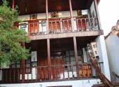
bünyesinde bar›nd›r›r. ‹lçe, el yap›m›
hal›lar› ve battaniyeleri ile meflhurdur.
Bu¤day, tütün ve meyve yetifltiricili¤i
ekonomi aç›s›ndan önem tafl›r.
The smallest host county of 2012
Aegean Cup with a population of
46.433. The history of the county,
dates back to 15000 BC but it is
known that Kula was a settlement
near Lydian city of Sardes. Between
the 7th and 11th centuries, Kula was
under the control of Byzantine
Empire and conquered by the Turks
in 12th century. One of the farest
locations, Kula is 124 km away from
Manisa city centre. It's 720 m above
sea level. have the youngest volcanic
mountains in Turkey. Handweaven
carpets and blankets of the county is
quite famous.
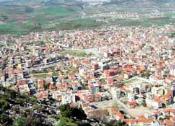
102 bin 666 kiflilik nüfusuyla Manisa
flehir merkezine 87 km uzakl›kta
bulunan Soma , Yunt Da¤›’n›n
eteklerinde yer almaktad›r. Linyit
kömürü kaynaklar›n›n oldukça fazla
oldu¤u ilçede, Soma Termik Santral›
ile de elektrik üretilmektedir. Türkiye
elektri¤inin %10’u buradan
karfl›lanmaktad›r. Soma’da ayr›ca
rüzgar enerji santralleri de
bulunmaktad›r. Tarih boyunca
Hititler, Lidyal›lar, ‹ranl›lar,
Makedonyal›lar, Bizansl›lar ve
Osmanl›lar bu bölgede hüküm
sürmüfltür.
With a population of 102,666, Soma
is 87 km away from Manisa city
centre. It locates hillside of Yunt
Mountain. Brown coal is the main
leading product while, there is also a
thermal power station in the district
which produces electricity. %10
electricity power of Turkey is
supplied from Soma Thermal Power
Station. On the other hand; wind
power reactors are also found in the
town. Throughout the history, many
empires reigned in Soma, such as
Hittites, Lydians, Persians,
Macedonians, Byzantines and
Ottomans.
Saruhanlı
Manisa il merkezine 20 km uzakl›kta yer
alan ve deniz seviyesinden 43 m
yükseklikte kurulmufl olan Saruhanl›’n›n
genel nüfusu 54 bin 160’t›r.
Saruhanl›’n›n kesin kurulufl tarihi
bilinmese de Saruhan Beyli¤i’nin
1313-1437 döneminde kuruldu¤u
düflünülmektedir. Osmanl›lar zaman›nda
150 haneli bir köy olan Saruhanl›, 1956
y›l›nda Manisa’ya ba¤l› bir ilçe haline
geldi. ‹lçe halk›n›n büyük bir k›sm›n›
1922 ile 1960 aras› Balkanlardan gelen
göçmenler oluflturur. Saruhanl› düz ve
verimli arazi olan Gediz ovas›nda yer
al›r. Bölgede en çok çekirdeksiz üzüm,
pamuk, m›s›r ürünleri yetiflmektedir.
Saruhanl› is 20 km far away from
Manisa city centre with a population
of 54.160 and 43 m above sea level.
However, the date of foundation has
been unknown yet, it is estimated that
it was established in 14th century
under the name of Saruhanl›
Principality 1313-1437. During the
Ottoman Empire reign, it was formed
from 150 villages while in 1956, it
has become a district of Manisa.
Majority of the population include
immigrants who have come from The
Balkans between the years 1922-
1960. Saruhanl› is located in Gediz
meadow.
Soma